Understanding Poland's Terrain Zones
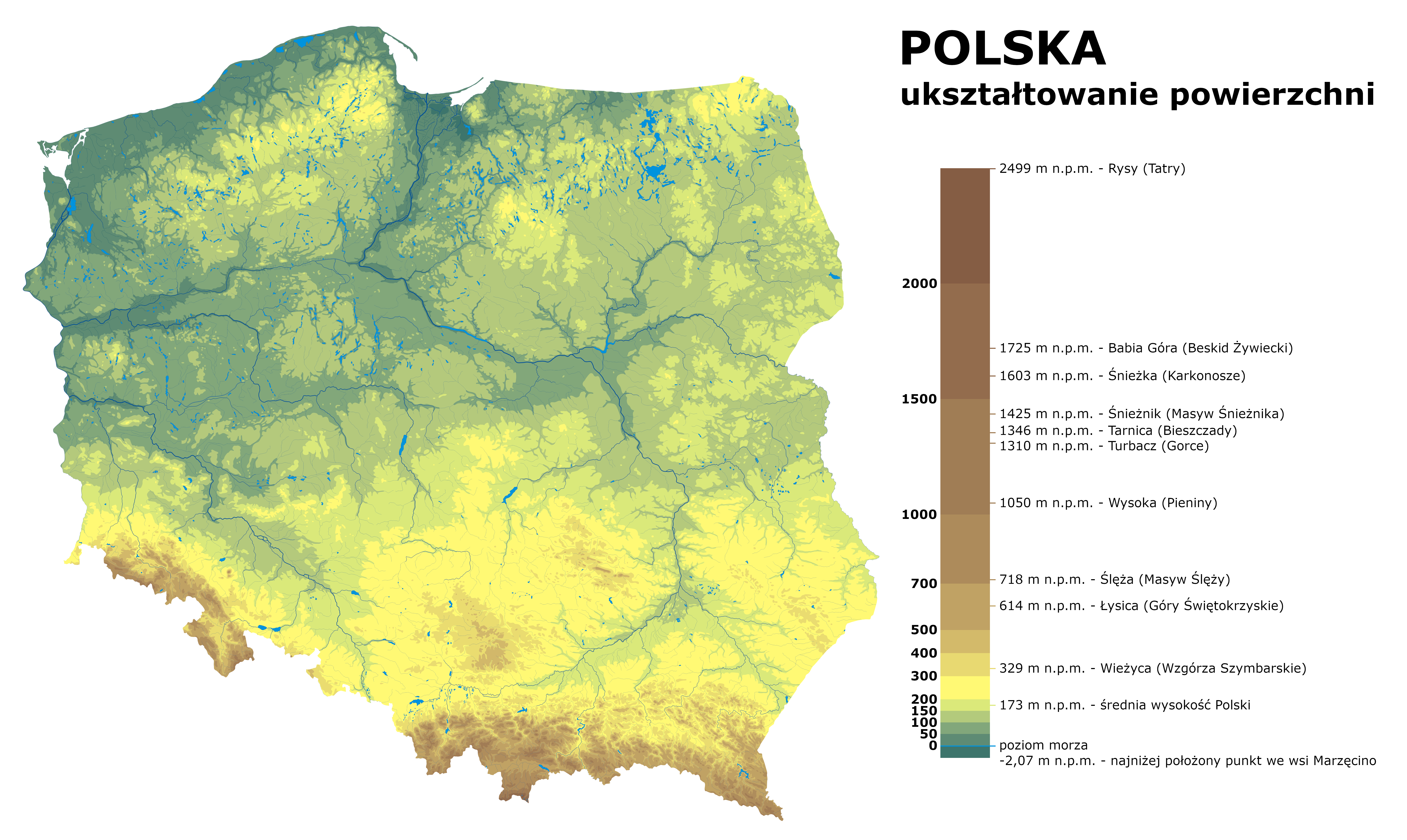
Poland is divided into six physiographic zones running in broadly east-west bands from the Baltic coast to the southern mountain ranges. Each zone presents distinct navigation characteristics that are predictable from the topographic map, provided the map reader knows what the symbols indicate about trafficability and landmark availability.
- Baltic Coastal Zone — sandy terrain, dune systems, coastal lagoons (Zalew Wiślany, Zalew Szczeciński). Flat but disorienting in fog.
- Coastal Lake District — Pomerania, Warmia-Mazury. Glacial moraines, numerous small lakes, mixed forest.
- Central Lowlands (Masovia, Kujawy) — broad river valleys, agricultural plains, extensive pine forests on sandy soils.
- Uplands (Wyżyny) — Lublin, Małopolska uplands; rolling karst and loess plateau terrain.
- Subcarpathian Basin — transition zone between uplands and mountains; moderate relief, river floodplains.
- Mountain Zone — Tatry, Beskidy, Bieszczady, Sudeten; significant elevation change, exposed ridgelines.
Masovian Lowlands: Flat Forest Navigation
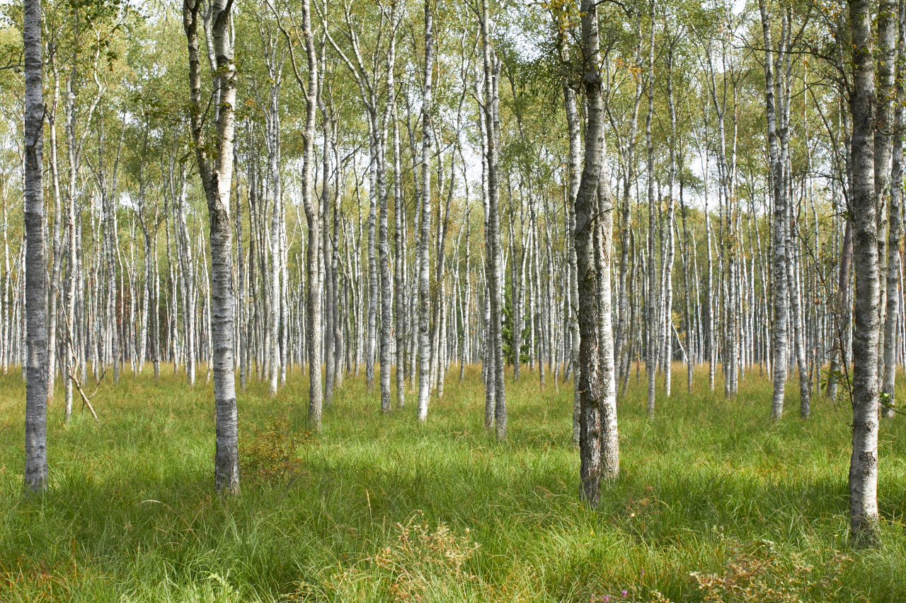
The central lowlands around Warsaw and south through Masovia are dominated by Scots pine monocultures planted on sandy, post-glacial outwash plains. These forests are managed by the State Forests (Lasy Państwowe) and divided into numbered forestry compartments (oddziały) separated by straight firebreak rides (drogi leśne).
The firebreak grid creates a navigational grid of its own — but it introduces a common error. Map-depicted firebreaks may not correspond to passable routes at all times: recent harvesting, windthrow, or replanting can block or obscure marked rides. Always expect discrepancies in recently revised forestry areas.
Forestry Compartment Posts
At the intersection of firebreak rides in Polish state forests, numbered concrete posts (słupki oddziałowe) mark compartment boundaries. Each post typically shows the compartment numbers of the four surrounding areas. These posts appear on 1:25 000 military maps as small black squares with numbers and can confirm position when the map edition is current. Civilian GUGiK maps do not always show compartment numbering.
Dead Reckoning in Flat Closed Canopy
Without visible landmarks, maintaining direction in pine forest requires dead reckoning: measuring distance by pace count and maintaining bearing with a compass. The key technique for straight-line travel is to align three trees ahead of you in the direction of travel before moving, then walk to the nearest while keeping the others in alignment. This avoids the natural drift that occurs when navigating toward a single distant point.
In Masovian pine forest, 5 km/h movement rate is a reasonable daytime estimate on firebreak tracks; cross-country through closed canopy without trails typically reduces to 2–3 km/h depending on undergrowth density.
Mazury Lake District: Wetlands and Mixed Forests
The Mazurian lake district (Pojezierze Mazurskie) in northeastern Poland contains over 2,000 lakes and extensive areas of marsh and peat bog. The terrain is the product of the last glacial maximum and is characterised by irregular, lobate lake shorelines, morainic ridges between 150 m and 310 m elevation, and poorly drained basins connecting lake systems.
Water as a Navigation Hazard
The map depiction of lakes and marshes in Mazury can understate their actual extent, particularly after wet springs or in periods of high water table. Small ponds and marshes that appear as separate features on a 1:50 000 map may be connected and impassable on the ground. The Biebrza river valley, further west, presents similar challenges: the national park area is criss-crossed by drainage canals, but the surrounding peat bogs are essentially impassable without established trails.
When planning routes in the Mazurian lake district, route selection should explicitly follow ridgelines between lake basins rather than attempting direct cross-country lines. The additional distance on a ridge route is almost always recovered in movement speed compared to struggling through marsh margins.
Landmark Use in Lake District Terrain
The lakes themselves are excellent navigation landmarks. A lake's distinctive outline — visible on the map — can be matched to ground observation from any elevated vantage point. Church towers in lakeside villages (Mikołajki, Ryn, Giżycko) are visible at considerable distance and appear reliably on current maps. Wind turbines, now numerous in the region, are not consistently shown on maps issued before 2015.
Carpathian Mountains: Hill Navigation
The Beskid ranges (Western and Eastern) and the High Tatry in the extreme south represent Poland's most demanding navigation terrain. Elevation change of 1,000–1,500 m within a few horizontal kilometres, combined with weather that can deteriorate rapidly, requires map reading competence beyond flat-terrain skills.
Contour Interpretation in High Relief
In mountain terrain, contour lines at 10 m or 20 m intervals appear closely packed. The ability to identify ridgelines and stream valleys from contour patterns — rather than relying on colour-coding — becomes critical. Streams in the Beskidy generally run perpendicular to main ridgelines, in V-shaped valleys. The main ridgelines are identifiable as watersheds: the zone where contour V-shapes reverse direction.
Trail waymarking (Polskie Towarzystwo Turystyczne, PTT system) uses coloured paint marks on trees and rocks. These are maintained on official tourist routes in national parks (Tatrzański Park Narodowy, Bieszczadzki Park Narodowy) but should not be relied upon off designated routes.
Tatry Specific: Polish-Slovak Border Navigation
The High Tatry ridge forms the Polish-Slovak state border. Both the Polish (TPN) and Slovak (TANAP) national parks use differing trail marking conventions. Maps of the Tatry are available from both Polish and Slovak publishers at 1:25 000 and 1:30 000 scales. The Polish PPWK/ExpressMap 1:25 000 series covers the Polish sector in detail. In above-treeline terrain, cairn lines (szlaki bez drzew) replace painted marks; these can be obscured by snow into late spring.
Sudeten Range: Valley and Ridge Navigation
The Sudeten (Sudety) mountains along the Czech-Polish border differ from the Beskidy in structure: they include distinct ridge-and-valley sequences with broader, more navigable ridgelines. The Karkonosze (Giant Mountains) contain Poland's highest non-Tatra peak, Śnieżka at 1,603 m. Above-treeline navigation on the Karkonosze plateau in poor visibility requires map and compass; the plateau is open and featureless in mist.
The Sowie Mountains (Góry Sowie) and Góry Stołowe (Table Mountains) in lower Sudeten present unusual tabular terrain — flat-topped sandstone plateaux with steep edges. The topographic representation of these features requires careful reading; cliff symbols on the map edge indicate abrupt drops that are not apparent from the contour pattern alone at the approach angle.
Seasonal Factors in Polish Navigation
Poland experiences four distinct seasons with significant effects on navigation conditions:
- Spring (March–May): Snowmelt raises river levels and inundates floodplain areas. Bogs and marshes reach maximum extent. Forest floor passability varies.
- Summer (June–August): High vegetation reduces visibility for landmark observation. Deciduous canopy obscures sky reference. Thunderstorm risk is highest in the afternoon in mountain zones.
- Autumn (September–November): Visibility improves after leaf fall. Deciduous forests become transparent to landmark sighting. Increasing daylight limitation from late October.
- Winter (December–February): Snow cover simplifies pace counting on flat terrain. Mountain passes may close. Frozen lakes provide crossing options not available in summer — but ice thickness must be assessed carefully.
References
- Kondracki, J. Geografia regionalna Polski. Wydawnictwo Naukowe PWN, Warsaw, 2011.
- General Directorate of State Forests (DGLP). Zasady hodowli lasu. Warsaw, 2012. Available at lasy.gov.pl.
- Tatrzański Park Narodowy. Mapa Tatrzańskiego Parku Narodowego, scale 1:25 000. ExpressMap, Warsaw, 2023.
- Biebrza National Park. Biebrzański Park Narodowy — informacje ogólne. Available at biebrza.org.pl.